This event has been ended!
Caminhando entre o Tejo e o Ocreza
Walking between the Tagus and the Office
Event by: Caminhando.pt
Location: Estação do Oriente, Av. Dom João II, Lisboa
Tickets: Get tickets
About event
Event: Walking between Tagus and Ocurity
Date: March 15 and 16, 2025
Registration deadline: February 28 2025
Event Description: "Walking between the Tagus and Ocurity - From the gates of Ródão to the gates of Almmão"
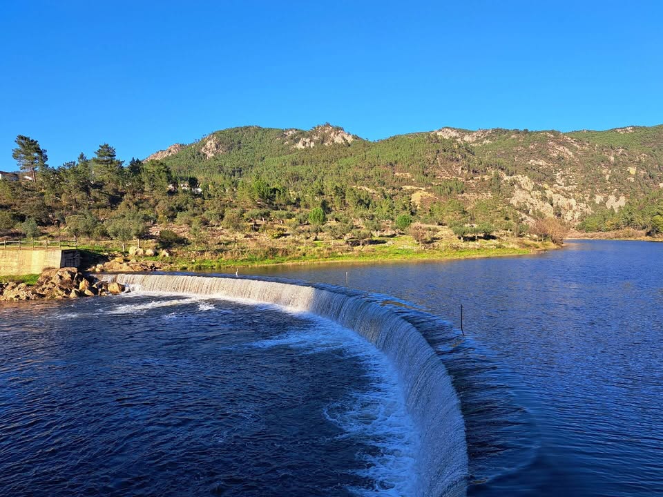
Magnificent walks along the banks of the Tagus, the OCurity and the Ribeira do Cobrão, having the opportunity to capture scenarios of excellence, from the gates of Ródão, to the island of virtues and the doors of Almourão, only to sharpen the appetite of the walkers. We will also visit the Figueira Schist Village, and a tour in Proença-a-Nova, where we will be housed well at the Hotel das Amoras. There will also be time to enjoy a boat trip to the natural monument of the gates of Ródão. Another event not to be lost!
These will be some of the most important places of interest to the various walks:
Natural Monument of the gates of Ródão (Tagus River)
Portas do Almourão (River Ocurity)
Ribeira do Foz do Cobrão and Fluvial Beach of Penedo dos Cágados
Moinhos Figueira
Proença-a-Nova
Vila Velha de Ródão (Ribeirinha Zone, King Wamba Castle, French Invasions)
Virtudes Island
Serra das Talhadas
Natural Landscapes
Time: Lisbon at 7:00
Return: Arrival at 19:30
March (Saturday)
Path of Foz do Cobrão (Almmourão doors)
The first part of the route follows to the banks of the Ocurity River in a way to large quarter cliffs where we could often observe the flight of the emphasis or the ottings in the waters of the river. Further on we find the doors of the Mourão Valley, Geositio classified in the Naturtejo Geopark and a place of a breath -cut beauty. It is with the eyes in this stunning landscape that we pass by the village of Chão das Cervas and climbed to the highest point of the course where we see the village of Valley of Cobrão. We then follow by Ribeira do Cobrão that will take us again to the Ocurity River, passing again through large quarter cliffs and the small river pool of Ribeira do Cobrão. Walking between olive trees and cultivation land we reached the mouth of the snake where we found the mills that once served the inhabitants on the banks of the river. Difficulty on the route: 3.5 (scale 1 to 5)
Path extension: 12 kms
Circular path
PREVISONED Duration: 3h45m
Portas do Almourão
The doors of Almourão are between the village of the Foz do Cobão (Vila Vila de Cobão Ródão) and Sobral Fernando (Proença-a-Nova), corresponding to the throat of the Ocurity River. It is a geological occurrence that results from the action of this river, whose waters ripped the imposing quartzitic escarpments, and a geositation classified in the Naturtejo Geopark, place of a breath-cut beauty. This diverse geological landscape supports very well -preserved ecosystems, which houses an important area of poultry nesting and other very important species, such as blue, otter, badge and squirrel. At this point, we came across a 400-meter-depth gorge that gives way to a valley with a wild and dazzling landscape, where we feel small in the face of the grandeur of nature. There is a constant presence of animal species with high protection status, among which emphasizes the colony of emphasis added in the rocks that flanks the Ocurity River, the black stork, the royal heron, the royal heron, and the okay eagle, among other species. Schist, practically flat and easy to circulate. Its central nucleus hides in its tangle the community oven. In its surrounding agricultural land villages of olive trees, they give rise to the "green gold" which was once the richness of the village. The first chart given to Proença-a-Nova dates from 1244 by the prior of the order of Hospital Frei Rodrigo Egidio. D. Manuel I reformed all the floods, and the "new charter" has the proença-a-nova in 1512. The justification of the name "cork" is related to the abundant production of cork and high number of hives (also called tenements) which, in a while, were of great importance in the region. March 16 (Sunday)
9h30 - Walk "to the conquest of King Wamba Castle"
This walk develops in ways in zigzag and we will pass some military monuments (buildings that were built and used in three important moments of military history: The Seven Years War, the War of Succession of Spain and the 1st French invasion, between the french seventeenth and XIX). We will climb the Sierra das Talhadas and with panoramic views of the breath. Upon arriving at King Wamba Castle, we enjoyed the landscape created by the Tagus River, the quartzitic ridges and the traces of the Romans' gold exploration in the Arneiro brandy, marked by an accumulation of rounded blocks in many hectares, on the left bank of the Tagus River. Wamba
King Wamba Castle rises in a leveraged escarpment to the Tagus River, over the gates of Rodão, in a place of surprising beauty and great strategic importance. It is believed that its origin retains at the time of the Muslim occupation and is related to the donation of the Territory of Sofa, by D. Sancho I, to the Order of the Temple, in 1199, although an anterior origin is admitted and oral tradition associates it with King Wamba, visigod king. The remaining Atalaia Tower was erected in the twelfth centuries to the thirteenth, by the Templars' nomination. A few meters is the temple of Our Lady of the Castle. As a construction for military purposes, it should be considered a watchman, although more complex than the common of these structures. During the Christian reconquest, it would have as its main functions the surveillance of the border line of the Tagus of Muslim forays from the southern. From the modern times, the castle would be used, particularly in the eighteenth and nineteenth century, as a base of artillery, in order to prevent the passage of the Tagus and the entrance to the Alentejo, according to an invasion route through Beira Baixa, as happened during the seven -year war and the 1st French invasion (1807). 5)
Trail Extension: 12 kms
Circular route
Expected duration: 4h00m
- Pic-nic or Snack Lunch in Vila Velha de Ródão
15h- Boat Tour Suggestion (Duration: 1h) Ródão
16h15- Lisbon Activity and Return Final
Equipment: Footwear and Suitable Clothing
Registration Fee:
The value includes:
- Transport from Lisbon to the places described in a 4-star hotel, with a small hotel with a hotel with Outdoor pool)
- 2 Walks and 2 Tours
- Group Dinner (Drinks Not Included)
- The Proposal Accommodation Option includes several room typology
- Guide and Monitoring Hiking
- Compulsory Insurance
Transportation Values
Double room value: 195 €
235 €
Values Without Transport
Double room value: 145 €
Individual room value: 185 €
Reserve value: 50 €
notes:
a) Registration is limited and accommodation options to exist at the height of the reserve.
b) routes may be changed according to climacteric conditions
c) In case of having a group interested in this trip contact us, we have personalized solutions
Date: March 15 and 16, 2025
Registration deadline: February 28 2025
Event Description: "Walking between the Tagus and Ocurity - From the gates of Ródão to the gates of Almmão"
Magnificent walks along the banks of the Tagus, the OCurity and the Ribeira do Cobrão, having the opportunity to capture scenarios of excellence, from the gates of Ródão, to the island of virtues and the doors of Almourão, only to sharpen the appetite of the walkers. We will also visit the Figueira Schist Village, and a tour in Proença-a-Nova, where we will be housed well at the Hotel das Amoras. There will also be time to enjoy a boat trip to the natural monument of the gates of Ródão. Another event not to be lost!
These will be some of the most important places of interest to the various walks:
Natural Monument of the gates of Ródão (Tagus River)
Portas do Almourão (River Ocurity)
Ribeira do Foz do Cobrão and Fluvial Beach of Penedo dos Cágados
Moinhos Figueira
Proença-a-Nova
Vila Velha de Ródão (Ribeirinha Zone, King Wamba Castle, French Invasions)
Virtudes Island
Serra das Talhadas
Natural Landscapes
Time: Lisbon at 7:00
Return: Arrival at 19:30
March (Saturday)
Path of Foz do Cobrão (Almmourão doors)
The first part of the route follows to the banks of the Ocurity River in a way to large quarter cliffs where we could often observe the flight of the emphasis or the ottings in the waters of the river. Further on we find the doors of the Mourão Valley, Geositio classified in the Naturtejo Geopark and a place of a breath -cut beauty. It is with the eyes in this stunning landscape that we pass by the village of Chão das Cervas and climbed to the highest point of the course where we see the village of Valley of Cobrão. We then follow by Ribeira do Cobrão that will take us again to the Ocurity River, passing again through large quarter cliffs and the small river pool of Ribeira do Cobrão. Walking between olive trees and cultivation land we reached the mouth of the snake where we found the mills that once served the inhabitants on the banks of the river. Difficulty on the route: 3.5 (scale 1 to 5)
Path extension: 12 kms
Circular path
PREVISONED Duration: 3h45m
Portas do Almourão
The doors of Almourão are between the village of the Foz do Cobão (Vila Vila de Cobão Ródão) and Sobral Fernando (Proença-a-Nova), corresponding to the throat of the Ocurity River. It is a geological occurrence that results from the action of this river, whose waters ripped the imposing quartzitic escarpments, and a geositation classified in the Naturtejo Geopark, place of a breath-cut beauty. This diverse geological landscape supports very well -preserved ecosystems, which houses an important area of poultry nesting and other very important species, such as blue, otter, badge and squirrel. At this point, we came across a 400-meter-depth gorge that gives way to a valley with a wild and dazzling landscape, where we feel small in the face of the grandeur of nature. There is a constant presence of animal species with high protection status, among which emphasizes the colony of emphasis added in the rocks that flanks the Ocurity River, the black stork, the royal heron, the royal heron, and the okay eagle, among other species. Schist, practically flat and easy to circulate. Its central nucleus hides in its tangle the community oven. In its surrounding agricultural land villages of olive trees, they give rise to the "green gold" which was once the richness of the village. The first chart given to Proença-a-Nova dates from 1244 by the prior of the order of Hospital Frei Rodrigo Egidio. D. Manuel I reformed all the floods, and the "new charter" has the proença-a-nova in 1512. The justification of the name "cork" is related to the abundant production of cork and high number of hives (also called tenements) which, in a while, were of great importance in the region. March 16 (Sunday)
9h30 - Walk "to the conquest of King Wamba Castle"
This walk develops in ways in zigzag and we will pass some military monuments (buildings that were built and used in three important moments of military history: The Seven Years War, the War of Succession of Spain and the 1st French invasion, between the french seventeenth and XIX). We will climb the Sierra das Talhadas and with panoramic views of the breath. Upon arriving at King Wamba Castle, we enjoyed the landscape created by the Tagus River, the quartzitic ridges and the traces of the Romans' gold exploration in the Arneiro brandy, marked by an accumulation of rounded blocks in many hectares, on the left bank of the Tagus River. Wamba
King Wamba Castle rises in a leveraged escarpment to the Tagus River, over the gates of Rodão, in a place of surprising beauty and great strategic importance. It is believed that its origin retains at the time of the Muslim occupation and is related to the donation of the Territory of Sofa, by D. Sancho I, to the Order of the Temple, in 1199, although an anterior origin is admitted and oral tradition associates it with King Wamba, visigod king. The remaining Atalaia Tower was erected in the twelfth centuries to the thirteenth, by the Templars' nomination. A few meters is the temple of Our Lady of the Castle. As a construction for military purposes, it should be considered a watchman, although more complex than the common of these structures. During the Christian reconquest, it would have as its main functions the surveillance of the border line of the Tagus of Muslim forays from the southern. From the modern times, the castle would be used, particularly in the eighteenth and nineteenth century, as a base of artillery, in order to prevent the passage of the Tagus and the entrance to the Alentejo, according to an invasion route through Beira Baixa, as happened during the seven -year war and the 1st French invasion (1807). 5)
Trail Extension: 12 kms
Circular route
Expected duration: 4h00m
- Pic-nic or Snack Lunch in Vila Velha de Ródão
15h- Boat Tour Suggestion (Duration: 1h) Ródão
16h15- Lisbon Activity and Return Final
Equipment: Footwear and Suitable Clothing
Registration Fee:
The value includes:
- Transport from Lisbon to the places described in a 4-star hotel, with a small hotel with a hotel with Outdoor pool)
- 2 Walks and 2 Tours
- Group Dinner (Drinks Not Included)
- The Proposal Accommodation Option includes several room typology
- Guide and Monitoring Hiking
- Compulsory Insurance
Transportation Values
Double room value: 195 €
235 €
Values Without Transport
Double room value: 145 €
Individual room value: 185 €
Reserve value: 50 €
notes:
a) Registration is limited and accommodation options to exist at the height of the reserve.
b) routes may be changed according to climacteric conditions
c) In case of having a group interested in this trip contact us, we have personalized solutions